
Barnhardt Trail
On March 22nd, the C Group of the Payson Packers met in the Stages parking lot at about 0815. It had rained all of the previous day so our planned hikes were under discussion. The original plan was for the group to split up. Those that wanted the more strenuous Barnhardt Trail hike were going there and the rest of the group were going to one of the Payson Area Trail System (PATS) hikes, the Monument Peak loop hike.
Since the heavy rain would make these trail somewhat muddy and/or treacherous, the majority of the group (15 or so), elected to take a fitness trail hike at the local community college. Six of us however, decided to risk the Barnhardt trail. Bonnie, the hike leader for the original hike, could fit all six of us into her truck, a nice 3 seater, 4 wheel drive. Off we went.
My hiking book, Hiking Arizona, (page 100), gives a description of the total 12.4 mile hike. We were only going to point 3, what we called the 2nd waterfall. So, the book gives the starting elevation at 4200 feet. Using one of our member's in-phone GPS, we had about a 1500 ft elevation gain at the peak of our hike.
Anyway, we managed to get to the trailhead from a very slick, gooey, muddy dirt 
road, about 4 miles from Highway 87. There are 3 trailheads at this point with a lot of parking. A very popular place. We headed into the canyon mouth, always going up. Fortunately, the trail switchbacks back and forth but not at a particularly steep grade in most places.
Along the way, you can see on the opposite canyon wall the severe geological 
stresses this mountain range was subject to. White quartz layered between red rock zigzags up and down the cliff face. Pretty dramatic. Far below, the stream was running well. What with all the rain from the day before, we were not surprised to see the water flowing. I suspect by late June, the stream bed may be dry.
There weren't a lot of flowers along the path, I had expected to see quite a few given the recent snow and rainfall and the warm weather this far south. Oh well. 
We met a few people on the trail, some stopped at view points where we could see the Moggollon Rim, covered with snow from yesterday's snowfall (while we got rain in Payson, just an hour north, the higher elevation of the rim, gave that area snow!) It was all very, very pretty! I noted as the sun came out from behind the remaining clouds, that the water and trees had diamond drops scattered on tips of blades and branches. The whole place sparkled.
At about mile 2.5, we came to the first waterfall. Bonnie had described it a a sort of cathedral space with this plume of water coming down the high cliff face. 
Once we got there, I totally agreed with her discription. Additionally a large pine tree stood right in the center, just in front of the cliff face. The little stream that was generated, ran across the trail and down to the main stream running out of the canyon.
At this waterfall, we met a group of 3 that had just come from farther up the trail where they described a second waterfall. We decided to have our snack break then rested, voted to go on up the trail to see this next waterfall. They described it as about 1/2 an hour or 45 minutes farther on. On we went. This part of the trail was steeper and rockier than the 1st part but we pushed on and sure enough, in about 30 minutes we were at the 2nd waterfall. 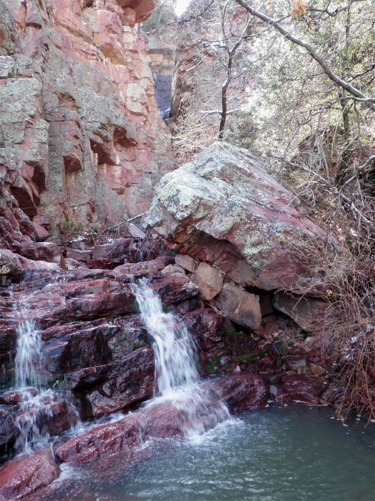
This waterfall is recessed into a chasm but can clearly be seen from the trail. It was a feather plume of water, falling from a high cliff, then running down the narrow canyon over several little rock steps till it crossed the trail. This part of the canyon still had snow cover and a lot of shade so it was a little chilly in there. While we were taking pictures, a couple of guys arrived so of course there were greetings and discussions of how nice this spot is.
We left them having a lunch break a few feet up the trail where there was some sun while we headed back down the canyon. 
We took a short break at the 1st waterfall, where Randy took some pictures of the small, moss covered pools. We all kept remarking on how nice the temperature was for the hike, not too cool, not too hot and the marvelous views we had of the rim.
Overall, the trail was not treacherous at all and we were glad we took the risk to come to the trail.
posted by Connie Cockrell | 11:59 AM
![]()
![]()
0 Comments:
Post a Comment
<< Home